logo

Field trip

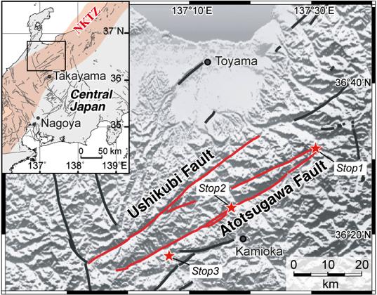
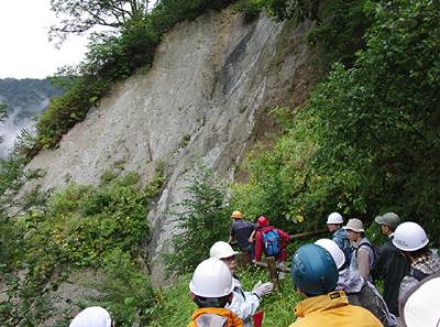
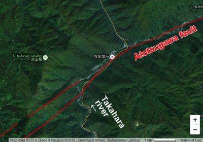
We visit outcrops of the Atotsugawa fault, which was ruptured by the 1858 M7.0 Hietsu earthquake on July 19, 2016.

The Latest Information for participants to the field trip from Prof. Kiyokazu Oohashi:
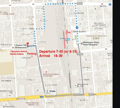
[Meeting place]
The parking lot of the Takayama-Shimin-Bunka-Kaikan(the venue of the symposium).
https://goo.gl/maps/4Cx4rfMfYet
*It will take about 10 min from Takayama Washington Hotel Plaza by walk (See a map below).

[Meeting and departure time]
We’ll take on 4 buses and 1 minivan (Boarding_list.xlsx ). Meeting time for the passengers of bus No.1, 2, and 3 is 7:30 AM. These buses depart at 7:45 AM. Meeting time for the passengers of bus No.4 and minivan is 8:00 AM. Bus No.4 and minivan will depart at 8:15 AM.
*We need to be on time. Your cooperation will be greatly appreciated.

[Lunch]
We’ll prepare box lunches for all participants to the field trip. So you just need to bring your drink.

[Another notice]
Please come with casual clothes which you would not mind getting dirty. It is also required to wear a hat or cap to prevent heatstroke. Some of the outcrops involve some danger. So please avoid taking business shoes or high heels.

Excursion guides; Akira Takeuchi (Toyama Univ.), Masakazu Niwa (Japan Atomic Energy Agency), Ryosuke Doke (Hot Spring Research Institute), and Kiyokazu Oohashi (Pricinpal leader: Yamaguchi Univ.)

If you have any questions,

Points of interests

item2 meetingplace

A venue and meeting place for the field trip.

item6 item10

Stop 1: Fault core of the Atotsugawa fault (the Magawa outcrop)

Stop 2: Displaced river and terraces of the Takahara river. Fault trace is derived from Active fault database of Japan, AIST.

item8

Stop 3: Paleodetachment of the Hida massif (the Funatsu mylonite zone)

The Atotsugawa fault is one of the most prominent active faults in Japan that caused the 1858 M7.0 Hietsu Earthquake, and is located in the Niigata-Kobe Tectonic Zone (NKTZ) which is a high strain-rate belt identified from GNSS observations. In the field trip, we will guide you to see geologic and geomorphic features of the Atotsugawa fault and surrounding terrain.

Reference:

For the 1858 Hietsu earthquake;
Research Group of Active Faults in Japan (1991) Active Faults in Japan, sheet maps and inventoriesrev. ed. (in Japanese), 437pp., Univ. of Tokyo Press, Tokyo, 1991.
For the Niigata-Kobe Tectonic Zone;
Sagiya et al. (2000) Continuous GPS Array and Present-day Crustal Deformation of Japan, Pure. Appl. Geophys, 157, 2303-2322, doi:10.1007/PL00022507
For the Funatsu mylonite zone;
Takahashi et al. (2010) Timing of mylonitization in the Funatsu Shear Zone within Hida Belt of southwest Japan: Implications for correlation with the shear zones around the Ogcheon Belt in the Korean Peninsula. Gondwana Research, 17, 102–115, doi:10.1016/j.gr.2009.04.008
For the Magawa outcrop;
Takagi et al. (2013). Geological framework and fission track dating of pseudotachylyte of the Atotsugawa Fault, Magawa area, central Japan, Island Arc, 22, 318–337, doi: 10.1111/iar.12036
 

Copyright © ISCD 2016 Local Organize Committee. ALL RIGHT RESERVED


item1